


LiDAR (Light Detection and Ranging) technology has become an essential tool for Scan to BIM services due to the construction industry’s demand for accurate and effective data collection.
LiDAR accurately depicts the built environment by measuring distances and constructing highly realistic three-dimensional (3D) reconstructions of existing structures using laser pulses.
The article will go into depth on LiDAR technology, its usage in Scan to BIM, and how it is transforming the way we approach building documentation and design.
What is LiDAR?
Light detection and ranging, or LiDAR for short, is a remote sensing technique that measures distances to Earth using light in the form of a pulsed laser.
These light pulses provide exact, three-dimensional information on the Earth’s structure and surface properties when paired with other data captured by the aerial system.
Here’s a breakdown of how LiDAR works:
- Laser Pulse Emission: Rapid laser pulses are emitted by LiDAR systems, and these pulses bounce off surfaces and objects in their path. The duration of time it takes for each pulse to return after reflecting off the surface is recorded by the system.
- Distance Measurement: LiDAR determines the distance to each point it encounters by timing the return of light to the sensor. We call this procedure “time-of-flight measurement.”
- Point Cloud Creation: A “point cloud,” or a collection of data points that represent the scanned region, is created using the distance information gathered from many laser pulses. X, Y, and Z are the three-dimensional coordinates for every point in the cloud.
- Penetration Capabilities: One of LiDAR’s specialties is its ability to see through obstacles such as dust, vegetation, and fog. This makes it very adaptable to various locations by enabling it to record data in a range of weather situations and coverages.
- High Accuracy and Detail: LiDAR is renowned for its high level of accuracy and detail. It can capture fine details over large areas, providing a precise digital map of features that might be missed by other surveying methods.
Learn how 3D laser scanning improves project accuracy and saves money in construction. For more insights, read the full article here.
Applications of LiDAR in Scan to BIM
The combination of LiDAR technology with Scan to BIM methods opens up a wide variety of possibilities in the AEC sector. This formidable combination excels in the following important areas:
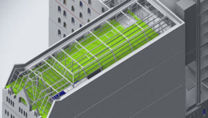
- As-Built Documentation
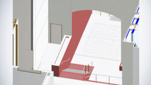
In Scan to BIM, one of the most important uses of LiDAR is the creation of very precise as-built documentation. LiDAR scans are utilized to precisely create BIM models by capturing existing structures, including their complex features.
This visual depiction of a structure’s or infrastructure’s current condition is very helpful for projects including facility management, refurbishment, and restoration. Architects, engineers, and facility managers may confidently plan their projects and make well-informed choices when they have access to an exact digital twin.
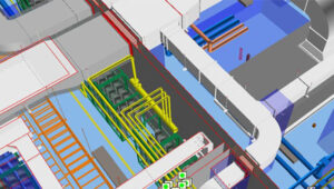
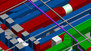
- Clash Detection and Coordination
When determining any conflicts or interferences between new and existing structures, LiDAR data is essential. Early in the design process, conflicts between mechanical, electrical, and plumbing systems may be found by merging LiDAR scans with BIM models.
By being proactive, this method improves coordination amongst many professions and lowers the possibility of expensive onsite mistakes and delays. LiDAR reduces unforeseen problems during construction, which facilitates more efficient project management.
- Topographical Surveys
Topographical surveys are a specialty of LiDAR, which provides accurate terrain data for infrastructure projects, urban planning, and landscape design. Engineers and designers may use LiDAR to record current ground characteristics, such as vegetation, elevations, and contours, to help them make well-informed choices. Grading, drainage design, and making sure that new projects blend in with the surroundings all depend on this data.
- Historical Preservation and Renovation
A non-invasive technique for obtaining the minute details of old buildings and structures is LiDAR scanning. By using this technology, the heritage of these locations is preserved for future generations in the form of a digital archive.
LiDAR data helps to create a smooth transition between new designs and the distinctive features of the current building when it comes to renovation projects. By using this application, historical structures are guaranteed to be repaired appropriately and to retain their cultural relevance.
Find out how combining 3D scanning with BIM makes renovation projects more efficient. Learn more by reading here.
- Quantity Take-offs and Cost Estimation
LiDAR data’s comprehensive nature simplifies quantity take-offs and offers precise measurements for cost and material calculations.
LiDAR lowers the possibility of cost overruns and allows more effective budgeting by producing accurate as-built models. By improving the entire financial management of building projects, this tool helps decision-makers make more informed choices.
Benefits of LiDAR in Scan to BIM
The AEC sector benefits greatly from the incorporation of LiDAR into Scan to BIM operations. The following main advantages demonstrate the importance of this technology:
- Accuracy and Precision: LiDAR’s extremely detailed point clouds guarantee that the measurements used to create BIM models are accurate and precise. This precision lowers the possibility of mistakes, cuts down on expensive rework, and improves the general caliber of building projects.
- Efficiency and Speed: Quick laser scanning enables speedier site evaluations, which shortens project schedules. Additionally, simpler processes and quicker project completion are facilitated by the effectiveness of LiDAR data processing and the capacity to produce BIM models rapidly.
- Increased Safety: By minimizing the need for workers to enter dangerous regions, LiDAR scanning increases the safety of construction sites. Accident risk may be reduced by doing scans remotely. Furthermore, before personnel are deployed, LiDAR data may detect possible safety dangers like structural problems or invisible obstacles, allowing for improved safety procedures and on-site risk management.
- Enhanced Coordination and Collaboration: LiDAR scans reduce conflicts between mechanical, electrical, and plumbing systems by facilitating early collision identification by giving a complete digital image of the current site.
- Flexibility and Richness of Data: LiDAR produces extremely dense point clouds that provide a plethora of information that may be used to a variety of tasks beyond original planning. This extensive dataset enables comprehensive research, including building management, daylighting studies, and energy efficiency evaluations.
Wrapping UP
The construction sector has shifted significantly as a result of the integration of LiDAR with Scan to BIM procedures. This strong mix improves accuracy and creates a more efficient process, which results in accurate project executions.
LiDAR is here to stay and evolve with Scan to Bim Services whilst improving decision-making, and resource allocation, reducing mistakes, and ensuring smooth coordination of operations in the AEC Industry.
FAQS
LiDAR (Light Detection and Ranging) is a remote sensing method that uses laser pulses to measure distances and create detailed 3D models of physical environments.
LiDAR provides highly accurate and detailed 3D scans of existing structures, which enhance the precision and efficiency of creating Building Information Models (BIM).
LiDAR offers improved accuracy, faster data collection, detailed modeling, and better integration with existing BIM tools, leading to more reliable and efficient building documentation.

